A Yankee Notebook
NUMBER 1826
July 18, 2016
LAKES OF THE CLOUDS
LAKES OF THE CLOUDS HUT, NH – I hiked slowly, uncertainly down through thick, blowing clouds over tumbled rocks, and gradually emerged into clearer air. I had almost forgotten the travails of descending the 1.5 miles from the summit of Mount Washington to the hut here at Lakes of the Clouds. The hut croo with their towering wood-frame packs skip over it like mountain goats, carrying trash up and fresh food and supplies down. Hundreds of hikers, in high season, tramp back and forth, north to Madison Hut or south to Mizpah Spring. Once upon a time – 61 years ago, to be exact – my friends and I did the same. We even ran now and then, making the most of the daylight. But now, supported by a pair of lightweight hiking poles and focused like a laser on my next potentially lethal step, I let myself gingerly down from boulder to boulder, and occasionally peeked to see if the hut was looking any closer than the last time I looked. It never did.
I silently channeled Edward Lear: “Forever keeping his weary eyes on that white-roofed hut on the far horizon.” Finally we passed the familiar bedrock hump that drops down into the tiny front yard of the hut. There were benches along the wall, sheltered from all but an east wind. Earlier arrivals sat writing in their journals, reading, or sitting in groups to share crackers, cheese, and wine in clear plastic bags. I went in to find my bunk; I’d asked the videographer who’d gone ahead to film the arrival to get me a lower. To my intense chagrin, he’d taken me literally, and I’d got a three foot-high cave right on the floor, its access and egress blocked by a ladder right in the middle of the opening. Well, at least it would be cozy, once I got in there.
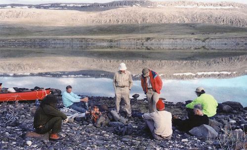
One group chatting over hors d’oeuvres, and offering to share their wine, had had a mishap on their way up the Ammonoosuc Ravine Trail from Crawford Notch. A young woman with them had fallen and dislocated her shoulder (I’d met her, with her arm in a sling, on her way to the summit as we came down). A chiropractor and a civil engineer in the group had debated what to do, and had finally googled on a cell phone for information and advice. The chiropractor had reduced the dislocation and bound up the arm. It was going to hurt a lot overnight, so they escorted her past the hut to the summit to catch a ride, and came back down.
The hut is located at timberline, near the spot where two intrepid hikers were caught by a summer storm many years ago and perished. Their deaths prompted the erection of an emergency shelter, which soon became a convenience shelter overrun with hikers. Today’s hut, which looks deceptively small, can accommodate and feed a hundred hikers. It uses power from a variety of mostly renewable sources, and leaves a remarkably small trace for such a busy place. We dined last night on green salad, ginger chicken, quinoa, and cake for dessert; this morning on terrific oatmeal, garnished with pineapple chunks, followed by bacon and scrambled eggs and coffee.
Nobody knows exactly how high Mount Washington and its surrounding peaks were just after their uplift and before millions of years of erosion and glaciation. But it’s still a very impressive pile of rock at 6288 feet. It dominates the skyline wherever it’s visible. Early settlers on the coast knew about it from the logs of Verrazzano, who spotted it from his ship in 1524, and the writings of John Smith, who spotted it in 1614 and called it “the twinkling mountain.” It’s amazing to me that it was first climbed by Darby Field, a Boston Irishman, in 1642, only 22 years after the Pilgrims landed in Massachusetts Bay. Darby recruited a few Abenakis to accompany him, but only two made it to the summit with him. Agiocochook, as they called it, was thought to harbor malevolent spirits. A sudden storm at the summit seemed to confirm this. Field brought back with him a few chunks of (probably) quartz that he thought to be diamonds, which started a rumor that there were jewels and treasures high on the mountain. Other climbers followed.
We’re here this weekend because of a program called Seek the Peak, through which fans of the famous weather observatory on the summit raise money to help support it. We’re hiking with a few of them, and will meet many more before we’re done. The weather looks unpromising: It’s about 40º on the peak, visibility 25 feet, relative humidity 100%, and winds gusting to 50 miles per hour. But it’s a Sunday morning in July, so we know that up there on that invisible peak the crowds will be crawling around it like ants on a sugar loaf. Some will have driven up – motorcycle guys love the 8-mile road; others will have come up on the cog railway and scurried into the summit restaurant and museum to get out of the weather; and a few – you can tell them by their poles, packs, sweaty bandanas, and air of bemused superiority – will have hiked up. There’ll be hundreds of selfies shot, with inscrutable gray mist looming behind. Then it’ll be down to the valley again, which will be in sunshine with a light overcast and a temperature in the 80s.
But first I’ve got to get this aged body up that slope so scattered with boulders that the bedrock of the mountain is only occasionally exposed. This is the downstream side of the mountain; the glacier that scoured clean the upstream side then dumped its load of spoil on this one. On a clear day you can see the towers on the summit before you set out; today we’ll be peering through the mist from one rock cairn to the next and being careful not to go amiss at any of the junctions along the way. It’s only about a mile and a half, and 1300 feet above us. The good news is that the uphill slog through boulders is a lot less risky than the downhill. And there’ll be lots of company: Peak Seekers in bright-colored parkas and fleece appearing a few moments after we hear them talking. Steve, our intrepid videographer, is going to stay back to hike with me, carrying a GoPro this time, instead of a big camera. It’s hooked Bluetoothily to his iPhone, so he can instantly transmit any stills he shoots, and they’ll be on the Internet before we even get to the top of the long, rocky slope. That is, if I get to the top of it. Time to lace ‘em up.